Executive Summary
The Opportunity
The Colerain-North Bend Gateway is a 2.55-acre, 15-parcel assemblage at the intersection of Colerain Avenue and North Bend Road in Mount Airy, Cincinnati. The site is fully controlled by the Hamilton County Land Reutilization Corporation (HCLRC) at a nominal acquisition cost of $1, and has been confirmed for development consideration by HomeBase CDC through the Mt. Airy CURE partnership.
This assessment evaluates the site across four development scenarios ranging from 57 to 165 units, each structured as a LIHTC 9% affordable housing deal. The site's combination of Qualified Census Tract status, CRA Expand tax abatement, donated land, and market rents that already align with 60% AMI limits makes this a strong LIHTC candidate—but the calculator-backed underwriting reveals that all four scenarios carry a funding gap of $4.3–5.8M that will require additional soft sources, deferred developer fee, or gap financing to close.
Site Characteristics
The site sits at a prominent commercial intersection with approximately 400 ft of Colerain Avenue frontage and 200 ft of North Bend Road frontage. The block is zoned CC-P-B (Community Commercial, Pedestrian) across 14 parcels and CC-M-B (Community Commercial, Mixed-Use) on the corner parcel—both permitting mixed-use development with an 85 ft height limit, no story cap, no FAR limit, and a density allowance of 700 sf/unit yielding up to 167 units by right.
Topography is the primary physical constraint. The buildable plateau along both street frontages sits at 925–943 ft elevation with cross-slopes of 6–16%. Behind the Colerain frontage, the grade breaks sharply—dropping 53 ft over 150 ft of plan distance at 35–40% slope. This cliff defines the eastern edge of the buildable area and creates a natural boundary for a green buffer zone.
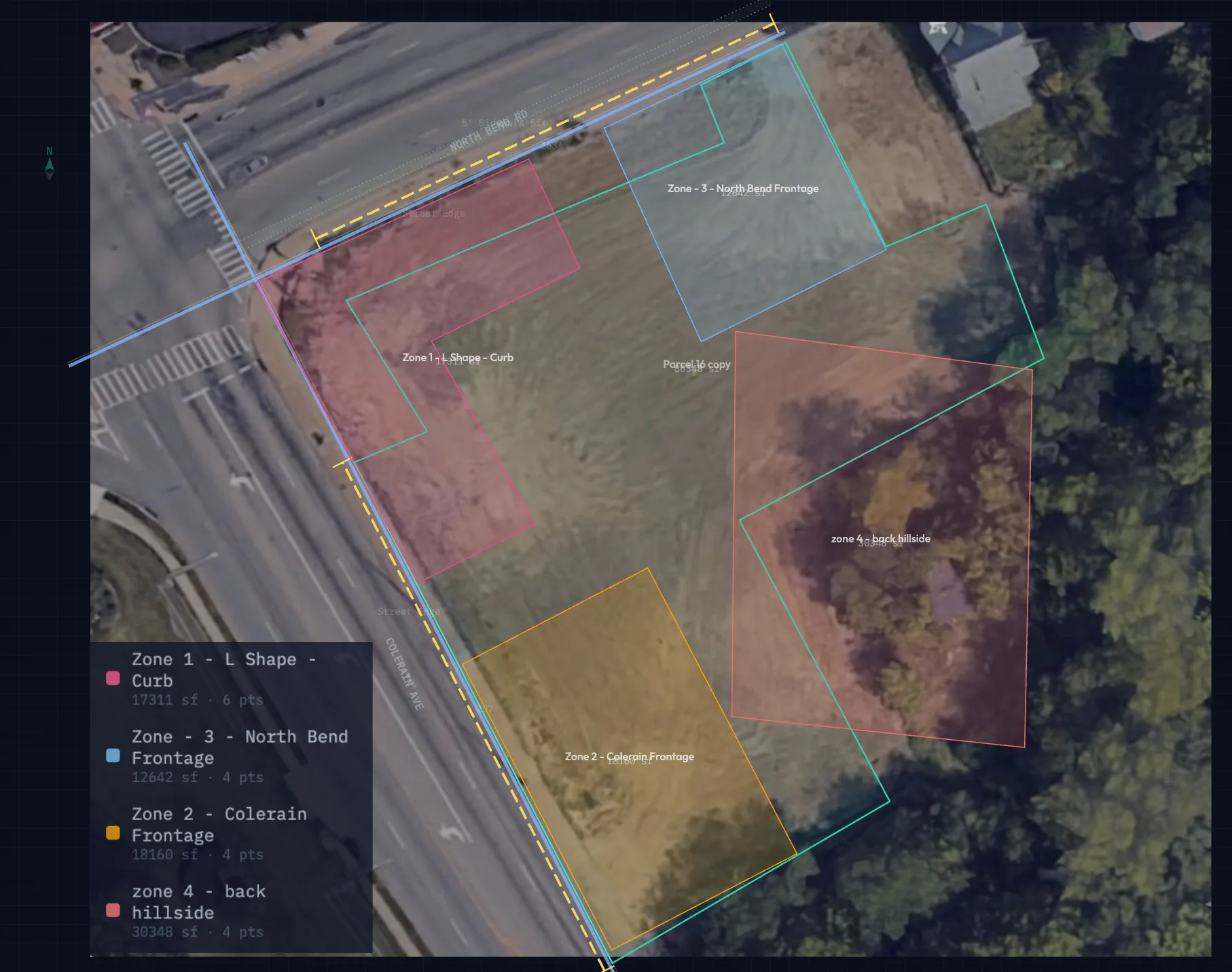
Development Concept
The site is organized into four zones based on topography, frontage, and zoning:
- Zone 1 — L-Shape Corner (15,700 sf): Mixed-use anchor building wrapping the Colerain/North Bend intersection. Ground-floor retail at the corner (2,500 sf), residential above, tuck-under parking exploiting the cross-slope. This is the gateway identity building.
- Zone 2 — Colerain Frontage (18,160 sf): Residential building(s) stepping down the south half of Colerain. Townhomes at smaller scale, walk-up apartments at larger scale. The steepening grade (10–14%) favors individually-stepped units.
- Zone 3 — North Bend Frontage (12,642 sf): Mixed-use building east of the L, with ground-floor flex/retail (1,500 sf). Activated only in the Three Buildings and Max Density scenarios.
- Zone 4 — Hillside Buffer (30,348 sf): Non-buildable. Trail system, bioswales for stormwater management, and community garden. This zone is the amenity differentiator—east-facing units look out over the tree canopy into the valley.
Scenario Matrix
Four scenarios test the relationship between project scale, capital structure, and CDC organizational capacity:
| Scenario | Units | Buildings | TDC | LIHTC Equity | Gap | CDC Profile |
|---|---|---|---|---|---|---|
| Starter | 57 | 2 | $28.9M | $20.2M | ($4.3M) | First LIHTC deal |
| Right-Sized | 87 | 2 | $38.8M | $27.2M | ($5.3M) | Proven operator |
| Three Buildings | 131 | 3 | $52.7M | $37.0M | ($5.8M) | Co-developer needed |
| Max Density | 165 | 3 | $60.5M | $42.5M | ($5.1M) | Major developer |
All four scenarios use the same financing structure: LIHTC 9% tax credit equity as the primary capital source, a conventional permanent loan sized by NOI/DSCR, and CRA Expand property tax abatement (75% for 12 years). The QCT 30% basis boost generates significant credit equity ($20–43M depending on scale), but a persistent $4–6M funding gap remains across all scenarios. This gap reflects the full-cost underwriting from the deal-structuring engine—including financing carry, conservative soft cost ratios, and reserves that hand estimates typically undercount. Closing the gap will require layering soft sources: deferred developer fee, HOME loans, FHLB AHP grants, Ohio Housing Trust Fund, CDFI soft seconds, and/or Cincinnati gap grants.
The LIHTC Advantage at This Location
The most important finding of this assessment is that 60% AMI rent limits are essentially equal to market rents in Mt. Airy. The rent haircut for going LIHTC is negligible:
| Unit Type | Market Rent | 60% AMI (net) | Difference |
|---|---|---|---|
| Studio | $950 | $950 | $0 |
| 1 BR | $1,150 | $1,134 | -$16 |
| 2 BR | $1,400 | $1,361 | -$39 |
| 3 BR | $1,650 | $1,419 | -$231 |
This means the LIHTC program is subsidizing the construction cost gap, not the rent gap. The credit generates $20–43M in tax credit equity depending on scale, while the revenue impact is minimal. This is the ideal LIHTC profile.
CDC Capacity Considerations
The site can support 165 units. LIHTC equity covers 70–85% of TDC at every scale, but a $4–6M gap remains that requires soft source layering. Beyond the capital stack, the binding constraint is organizational capacity. A $60M LIHTC deal requires:
- A dedicated development team managing $3–5M/month in construction draws
- A syndicator relationship—the tax credit investor will underwrite the CDC's capacity before committing equity
- 15+ years of LIHTC compliance infrastructure (income verification, unit mix monitoring, annual reporting)
- Asset management for 100+ units indefinitely
Recommended Path
Phase the project by CDC growth stage. Start with the L-building (Zone 1, 57 units, ~$29M TDC) as a single LIHTC application, potentially with a co-developer. The ~$4.3M gap on Phase 1 is addressable with deferred developer fee (~$1.4M), HOME ($110k), FHLB AHP ($85k), Ohio HTF ($60k), CDFI ($75k), Cincinnati gap grant ($50k), and sponsor equity or additional state sources for the remainder. Use Phase 1 to build syndicator relationships and compliance infrastructure. Pursue Zones 2 and 3 as separate LIHTC applications once Phase 1 is stabilized. Each phase builds the CDC's track record for the next.
Comparable Scale
For context, this project at full buildout (165 units, $60.5M TDC) is comparable in scale to the College Hill Station mixed-use development on Hamilton Avenue—a multi-building, transit-oriented project that combined LIHTC, CRA, and gap financing across phased delivery. The Colerain-North Bend site has similar advantages: gateway corner, public land, and strong overlay incentives. The difference is that College Hill had an established development team from the outset; HomeBase/CURE may need to build toward that capacity through phasing or partnership.
Key Risks
- Funding gap requires soft source layering. The engine shows a $4.3–5.8M gap across all scenarios after LIHTC equity and permanent debt. This is typical for new-construction affordable deals in Cincinnati—it means the project needs 3–5 additional soft sources (HOME, FHLB AHP, Ohio HTF, CDFI, deferred fee) to close. Each source has its own application cycle and compliance requirements.
- 9% LIHTC allocation is competitive. Ohio awards credits through a scored Qualified Allocation Plan. QCT status, donated land, and CRA abatement strengthen the application, but the allocation is not guaranteed.
- Construction cost sensitivity. The $210/sf assumption is based on RS Means Q1 2026 Cincinnati metro data. The engine applies this to full gross building area including circulation, which produces higher TDCs than net-rentable-only estimates. A 14–18 month LIHTC application-to-closing timeline means construction starts in late 2027 or 2028. Even modest cost escalation widens the gap.
- DSCR at 1.16x is below target. All four scenarios produce a debt service coverage ratio of 1.16x, below the typical 1.25x lender minimum. This constrains permanent loan sizing and may require interest rate buydowns, longer amortization, or subordinate debt to reach closing.
- Hillside site work. The $450k site extraordinary budget for retaining walls, stormwater, and utility connections is a preliminary estimate. Geotechnical investigation is needed before design development to confirm foundation conditions on the 12–16% slopes.
- Competing disposition. Parcels 022800030019 (5460 Colerain, $596k sale in 2024) and 022800030064 (2559 N Bend, $3.3M adjacent sale in 2025) flag concurrent commercial assembly activity in the area. Monitor for competing interests during the predevelopment period.
Methodology & Sources
Site Data
- Parcels
- Hamilton County Auditor via CAGIS API
- Geometry
- CAGIS parcel boundaries, EPSG:3735 projection
- Topography
- USGS 3DEP 1m DEM + CAGIS LiDAR
- Soils
- USDA NRCS gSSURGO via Web Soil Survey
- Zoning
- Cincinnati Municode, confirmed against CAGIS zoning layer
Financial Assumptions
- Construction
- RS Means 2026, Cincinnati metro adjustment
- Rents
- CoStar Cincinnati Q1 2026, Mt. Airy submarket
- AMI Limits
- HUD FY2025 Income Limits, Hamilton County
- QCT
- HUD QCT2026 dataset (huduser.gov), Tract 85.01
- CRA
- City of Cincinnati CRA Expand program schedule
- Cap Rates
- CoStar Cincinnati multifamily Q1 2026
Underwriting Engine
- TDC
- Site-engine deal-structuring-engine v1
- LIHTC
- 9% credit, 10yr period, $0.92 pricing
- Debt sizing
- NOI ÷ DSCR (1.25x min), 6.25%, 30yr amort
- Overlays
- QCT 30% basis boost, CRA 75%/12yr abatement
What This Is Not
- Appraisal
- No. Preliminary feasibility only.
- Engineering
- No. Geotech & civil needed.
- Legal
- No. Title work & entitlements required.
- Commitment
- No. No financing commitments exist.
About This Assessment
This is a Phase Zero pro forma light—a conversation starter, not a financing commitment. It answers "is this worth pursuing?" before anyone commits predevelopment capital to architects, engineers, and attorneys. The analysis uses deterministic site data, published financial benchmarks, and a calculator-backed underwriting engine to evaluate feasibility across multiple scenarios. All assumptions are documented and adjustable.
A full underwriting assessment—with sensitivity analysis, Monte Carlo simulations, construction scheduling, lender-ready pro formas, and third-party market studies—is the next step if the CDC decides to move forward. See the Roadmap tab for the 30/60/90 day action plan and what that full assessment would include.
Site Overview
Identity
- Site
- Colerain-North Bend Gateway
- Neighborhood
- Mount Airy
- Municipality
- City of Cincinnati, OH
- Address
- COLERAIN AVE + 9 more
- Lot Frame
- 397.68 ft × 472.26 ft
- Total Area
- 111,182 sf / 2.55 ac
- Centroid
- -84.5696, 39.1909
Control
- Entity
- Hamilton County Land Reutilization Corp.
- Status
- confirmed
- Confirmed
- 2026-03-15
- Source
- HomeBase / Alexis Heidenreich
- Acquisition
- $1 + $3,500 closing
Zoning
- Primary
- CC-P-B × 13 parcels
- Corner
- CC-M-B × 1 parcel
- Residential
- SF-6-MH × 1 parcel
- Max Height
- 85 ft (CC zones)
- Density
- 700 sf/unit → 136 units
- Illustrative
- 158 units (sitewide)
Overlays
- CRA
- Expand 75% / 12 yr
- Hillside
- yes
- Opportunity Zone
- no
- Historic
- no
- Flood Zone
- no
- QCT
- unverified
Parcels
| Address | ID | Zoning | Slope | Elevation | Status | Role |
|---|
Terrain Analysis
Slope Analysis
Buildable Zone 6–16% slope
| Parcel | Role | Avg Slope | Elevation | Drop |
|---|---|---|---|---|
| 035 (2565 N Bend) | N Bend extension | 6% | 925–931 ft | 6 ft |
| 036 (ROW sliver) | N Bend edge | 8% | 926–930 ft | 4 ft |
| 049 (5448 Colerain) | Colerain frontage | 9% | 925–937 ft | 12 ft |
| 105 (5442 Colerain) | Colerain frontage | 10% | 923–937 ft | 14 ft |
| 020 (5456 Colerain) | Colerain frontage | 11% | 926–938 ft | 12 ft |
| 033 (2563 N Bend) | N Bend extension | 11% | 915–931 ft | 16 ft |
| 104 (5454 Colerain) | Colerain frontage | 11% | 926–937 ft | 11 ft |
| 019 (5460 Colerain) | CC-M-B corner anchor | 13% | 928–940 ft | 12 ft |
| 018 (ROW sliver) | N Bend edge | 14% | 931–942 ft | 11 ft |
| 034 (5430 Colerain) | Colerain frontage | 14% | 908–936 ft | 28 ft |
| 017 (2563 N Bend) | N Bend frontage | 15% | 930–943 ft | 13 ft |
| 064 (2559 N Bend) | N Bend frontage | 16% | 911–943 ft | 32 ft |
Hillside / Non-Buildable >25% slope
| Parcel | Role | Avg Slope | Elevation | Drop |
|---|---|---|---|---|
| 247 (N Bend Rd, no #) | Hillside | 27% | 905–930 ft | 25 ft |
| 016 (Colerain Ave, no #) | Hillside | 35% | 873–926 ft | 53 ft |
| 048 (5430 Colerain REAR) | Hillside | 40% | 870–923 ft | 53 ft |
Development Zones
Zone 1 — L-Shape Corner anchor_mixed_use
Zone 2 — Colerain Frontage residential
Zone 3 — North Bend Frontage mixed_use
Zone 4 — Hillside Buffer green_buffer
Concept Renderings
Roadmap & Next Steps
Project Timeline
Decision Flow
30 / 60 / 90 Day Action Plan
0–30 DAYS Alignment & Capacity
- Complete Phase Zero site analysis & pro forma lightCo-Llab
- Verify QCT status (Tract 85.01 confirmed)Co-Llab
- Confirm site control via HCLRCHomeBase
- Present workbook to HomeBase/CURE leadershipCo-Llab + HomeBase
- CDC capacity self-assessment: staffing, track record, compliance readinessHomeBase
- Select target scenario (Starter / Right-Sized / Three Buildings / Max)HomeBase + Co-Llab
- Identify 2–3 potential co-developer partners (if needed for selected scale)HomeBase
30–60 DAYS Pre-Development Scoping
- Co-developer interviews & LOI (if applicable)HomeBase
- Commission geotechnical investigation (hillside slopes, foundation conditions)Co-Llab / Engineer
- Phase I environmental site assessmentConsultant
- Preliminary title work on all 15 parcelsAttorney
- Soft source inventory: identify which gap programs are open, deadlines, and dollar limitsCo-Llab
- OHFA QAP review: confirm scoring criteria, application deadlines, competitive landscapeCo-Llab
- Full underwriting: sensitivity analysis, best/worst/base case scenariosCo-Llab
60–90 DAYS Design & Application Prep
- Architect RFP / selection for schematic designHomeBase + Co-Dev
- Schematic site plan based on selected scenario + geotech findingsArchitect
- Syndicator pre-engagement: capacity presentation, preliminary LOICo-Dev / HomeBase
- CRA Expand application (if not already filed)HomeBase
- Soft source applications: HOME, FHLB AHP, Ohio HTF (match to open cycles)Co-Llab + HomeBase
- LIHTC 9% application draft & scoring self-assessmentCo-Llab + Co-Dev
90+ DAYS Beyond Phase Zero
- Submit OHFA 9% LIHTC applicationDevelopment team
- Construction loan engagement & term sheetDevelopment team
- Design development & construction documentsArchitect
- GC procurement & pricingDevelopment team
- Financial closingDevelopment team
- Construction start (Phase 1 — Zone 1 L-building)GC
Outstanding Questions for CDC Review
- Organizational capacity: Has HomeBase completed a LIHTC deal before? What was the scale? Do they have compliance staff?HomeBase
- Co-developer relationships: Does HomeBase have existing relationships with experienced LIHTC developers in Ohio?HomeBase
- Scale appetite: Which scenario aligns with the CDC's 3–5 year strategic plan? Is phasing preferred?HomeBase
- Product vision: Is 100% affordable rental the right product, or is there appetite for mixed-income or a for-sale component?HomeBase + Community
- Retail tenanting: Is there a known tenant for the corner retail space? A letter of intent strengthens the LIHTC application.HomeBase
- Community engagement: Has the neighborhood been engaged on the development concept? Any known opposition or support?HomeBase
- Competing interests: Status of the $596k / $3.3M sale activity on parcels 019 and 064?HomeBase
- HCLRC disposition timeline: Are there any parallel disposition commitments or deadlines on these parcels?HomeBase / HCLRC
What Full Underwriting Would Include
Sensitivity Analysis
- Hard cost
- $190 / $210 / $230 / $250 per sf
- Vacancy
- 3% / 5% / 7% / 10%
- Rent growth
- 0% / 1% / 2% / 3%
- Interest rate
- 5.5% / 6.25% / 7.0% / 7.5%
- Credit pricing
- $0.86 / $0.89 / $0.92 / $0.95
Simulation Runs
- Monte Carlo
- 1,000+ iterations on cost/rent/rate
- Best case
- Low cost + high rents + low rates
- Worst case
- High cost + flat rents + high rates
- Break-even
- What inputs make the gap = $0?
- Stress test
- 12-month vacancy + 15% cost overrun
Construction Detail
- Draw schedule
- Monthly construction draws + S-curve
- Interest carry
- Actual accrual, not lump estimate
- GC pricing
- Real bids, not RS Means benchmarks
- Geotech
- Foundation design from soil borings
- Value engineering
- Where to save without cutting quality
Lender-Ready Package
- 15-year DCF
- Year-by-year cash flow + exit
- Tax credit schedule
- Annual credits, equity draws, recapture
- Compliance plan
- Income verification, reporting, monitoring
- Market study
- Third-party rent comp + demand analysis
- Appraisal
- As-completed + as-stabilized values